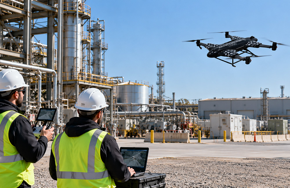
Supervised autonomous UAV inspection at an industrial facility. | Source: ZenaDrone
An autonomous drone can complete a carefully planned inspection route in a controlled environment and still struggle with the same route at an operating industrial facility. A steel structure may obstruct satellite signals, reflective equipment may distort depth measurements, and a wind gust may push the aircraft outside its planned trajectory. Each disturbance can be manageable in isolation. The difficulty emerges when several occur simultaneously.
This exposes a fundamental challenge in industrial drone autonomy: performance depends on interactions between subsystems whose assumptions are rarely independent.
A navigation algorithm may estimate position accurately under favorable sensing conditions. An obstacle detector may identify nearby structures during controlled testing. A flight controller may maintain stable tracking under a nominal payload. None of these results independently establishes that the integrated system can safely complete an inspection near energized infrastructure, confined structures, or operating machinery.
Reliable deployment requires engineers to understand how uncertainty propagates through localization, perception, planning, control, and inspection-data acquisition. It also requires evidence that the system can recognize when its estimates are no longer trustworthy.
Why industrial environments challenge autonomous navigation
Industrial facilities introduce environmental conditions that are difficult to reproduce in laboratory demonstrations.
Metallic surfaces, repetitive structural patterns, narrow access corridors, moving equipment, airborne particulates, and changing illumination can affect multiple sensors simultaneously. These conditions create both geometric constraints and uncertainty in the information available to the autonomy system.
Consider a hypothetical UAV inspecting pipework beside a steel-framed processing facility.
As the aircraft approaches the structure, GNSS measurements become less reliable. Repetitive pipes complicate visual feature matching, while reflective surfaces produce inconsistent depth observations. Meanwhile, the flight controller must reject aerodynamic disturbances caused by nearby structures.
The resulting problem is not simply inaccurate positioning. The autonomy stack must decide whether its remaining localization confidence supports continued flight, whether detected free space is sufficiently reliable, and whether the planned maneuver remains dynamically feasible.
These decisions are coupled. A localization error can corrupt obstacle coordinates, while a delayed perception update can cause the planner to act on geometry that no longer represents the aircraft’s surroundings.
The practical engineering objective is therefore not uninterrupted autonomous operation under every condition. It is predictable behavior within a defined operational envelope, including when that envelope is exceeded.
GNSS limitations and the localization problem
Global Navigation Satellite System (GNSS) positioning provides an important absolute reference for outdoor autonomous UAV navigation. However, industrial structures introduce several failure mechanisms.
Buildings, tanks, and overhead equipment can block direct satellite signals. Reflections from metallic surfaces create multipath interference, causing a receiver to process signals that have traveled indirect paths.
Real-time kinematic (RTK) positioning can improve accuracy by using carrier-phase measurements and correction data. However, RTK does not eliminate obstruction, multipath, cycle slips, or poor satellite geometry. A fixed ambiguity solution should not be treated as an unconditional guarantee of accurate positioning.
Combining absolute and relative localization
An inertial measurement unit (IMU) estimates angular velocity and specific force. Integrated inertial measurements support high-frequency motion propagation, but bias and noise cause errors to accumulate over time.
Visual-inertial odometry (VIO) combines camera observations with inertial measurements to estimate relative motion. Published work such as VINS-Mono demonstrates nonlinear optimization approaches that integrate visual and inertial constraints for state estimation.
Lidar-based odometry provides another approach, using geometric correspondence between successive scans. LIO-SAM, for example, combines lidar and inertial measurements in a factor-graph framework with mapping and loop-closure capabilities.
These approaches have different weaknesses. Visual methods depend on illumination, image quality, and observable features. Lidar methods can struggle with insufficient geometric constraints, adverse returns, or sensor-specific limitations.
Simultaneous localization and mapping (SLAM) additionally maintains a representation of the environment while estimating the robot’s pose. Loop closure can correct accumulated trajectory drift when a previously visited location is recognized, although incorrect associations can introduce significant map errors.
For industrial UAVs, engineers must also distinguish local consistency from global accuracy. A drone may maintain a stable relative trajectory while its estimated position gradually diverges from the facility’s surveyed coordinate system.
This distinction becomes critical when an inspection requires repeatable measurements at known asset locations.
Obstacle avoidance is more than detecting objects
Obstacle avoidance is often described as a perception problem. In operational UAV systems, it is an end-to-end timing and control problem.
A typical pipeline must acquire sensor measurements, estimate obstacle geometry, update the local environment representation, generate a collision-free trajectory, and issue commands that the aircraft can physically execute.
Each stage introduces latency and uncertainty.
Sensor limitations affect the available flight envelope
Lidar provides active range measurements and can support geometric mapping under varying visible-light conditions. However, transparent materials, highly reflective surfaces, thin wires, and unfavorable incidence angles can produce missing or misleading returns.
Stereo vision estimates depth from image correspondence. Its performance depends on camera geometry, texture, illumination, and disparity estimation. Depth uncertainty generally increases with distance for a fixed stereo baseline and disparity uncertainty.
Active depth cameras introduce their own range, illumination, interference, and surface-response constraints.
No single sensing modality provides reliable coverage of every industrial obstacle. A practical design must account for sensor field of view, blind regions, minimum detection range, and the possibility that a hazard remains unobserved.
Planning latency becomes physical distance
For a simplified one-dimensional braking model, the distance required to respond to an obstacle can be approximated as:
d_required ≈ vT + v²/(2a)
Here, v is the aircraft’s speed toward the obstacle, T is the combined detection-to-control delay, and a is the achievable deceleration magnitude.
This model assumes constant speed during the delay and constant deceleration afterward. It excludes additional clearance margins, uncertainty, wind, and complex multi-axis flight dynamics.
Nevertheless, it illustrates why latency matters. Doubling flight speed doubles the distance traveled during processing delay and quadruples the idealized braking-distance term.
A collision-avoidance system must therefore be evaluated against the aircraft’s actual maneuvering capability, not simply its obstacle detection range.
Dynamic obstacles add another complication. A path considered clear at the beginning of a planning cycle may no longer be safe when the corresponding control command is executed.
Sensor fusion and state estimation under real-world conditions
Sensor fusion improves navigation by combining measurements with complementary characteristics. It also introduces dependencies that must be explicitly managed.
An extended Kalman filter (EKF), commonly used for state estimation, propagates the system state through a motion model and corrects that prediction using sensor observations.
The measurement update depends on the estimated uncertainty of both the prediction and the observations. If those uncertainty models are inaccurate, the filter may become overconfident.
For example, GNSS measurements affected by multipath may exhibit correlated errors that are poorly represented by a simple independent-noise assumption. Accepting such measurements with excessive confidence can pull the state estimate away from the true trajectory.
Innovation residuals and normalized innovation squared tests can help identify inconsistent measurements. However, statistical gating depends on appropriate noise models and does not guarantee detection of every failure.
Calibration and synchronization are part of navigation
A camera and IMU must have accurately characterized spatial transformations and timing relationships.
Even a small temporal offset can create systematic visual-inertial estimation errors during rapid rotation. Incorrect extrinsic calibration can similarly produce inconsistent motion estimates.
The Kalibr calibration framework provides established methods for estimating camera-IMU spatial and temporal relationships.
Engineers should also monitor estimator consistency, covariance behavior, measurement rejection rates, and the duration for which the system can operate without reliable absolute position updates.
A crucial distinction is that estimator covariance represents uncertainty under the assumed model. It is not necessarily a complete measure of actual error when the model itself is wrong.
Environmental disturbances and flight control reliability
Autonomous navigation cannot be separated from the aircraft’s flight dynamics.
Wind gusts introduce external forces and moments that disturb trajectory tracking. Near buildings, airflow can become spatially variable, producing disturbances that differ from those encountered in unobstructed flight. For additional operational context, an overview of drone wind resistance levels provides a practical explanation of wind ratings and operating constraints; those ratings still require interpretation against aircraft configuration and site conditions.
Payload changes affect mass, center of gravity, inertia, and power requirements. Vibration can degrade IMU measurements and camera image quality, particularly when mechanical isolation and filtering are insufficient.
Actuator saturation creates another important limitation. A controller may calculate a corrective command that the motors cannot deliver because of thrust limits, battery voltage, or competing attitude-control demands.
Control-loop stability must therefore be evaluated across expected payload configurations and operating conditions.
Embedded computing introduces competing constraints
Autonomous UAVs often execute localization, perception, mapping, planning, communications, and mission management on limited onboard computing resources.
Higher-resolution sensing may improve geometric detail but increase processing load, memory use, power consumption, and latency.
A computationally intensive SLAM update can also compete with perception or planning workloads.
Engineers need to characterize worst-case execution times, deadline misses, scheduling behavior, and degraded-operation strategies rather than relying solely on average processor utilization.
A navigation system that produces accurate estimates too late for the controller to use them is not operationally reliable.
Why autonomous inspection data can still be unreliable
Successfully navigating an inspection route does not guarantee that the resulting measurements are suitable for engineering decisions.
Navigation accuracy and inspection-data accuracy are related but distinct.
A UAV may maintain a stable position while capturing blurred imagery, poorly calibrated thermal measurements, or insufficiently overlapping photographs.
For photogrammetric inspection, reconstruction quality depends on camera calibration, image geometry, surface texture, exposure, and the distribution of viewing angles. High image overlap alone cannot compensate for weak geometry or systematic calibration errors.
Georeferencing adds further dependencies, including coordinate transformations, surveyed control, camera-to-body alignment, and synchronization between position estimates and image capture.
Thermal imaging introduces different limitations. Apparent temperature depends on emissivity, reflected radiation, viewing geometry, atmospheric conditions, and instrument calibration. A thermal anomaly should not automatically be interpreted as a confirmed equipment defect.
Lidar inspection similarly depends on scan geometry, range noise, incidence angle, point density, and motion compensation.
For repeat inspections, engineers should evaluate whether the same physical feature can be measured consistently across missions.
That requires separating repeatability from absolute accuracy and recording sufficient metadata to identify changes in sensing conditions. An inspection workflow should therefore validate both the flight trajectory and the quality of the collected engineering evidence.
Human oversight, failure recovery, and operational safety
Autonomous operation does not remove the need for supervisory control.
A robust system should define the conditions under which it can continue, pause, return, land, or transfer authority to a human operator.
These decisions require explicit fault-handling logic.
Loss of GNSS alone may not justify terminating a mission if alternative localization remains sufficiently reliable. However, simultaneous localization degradation and restricted maneuvering space may make continued autonomous flight unacceptable.
Return-to-home behavior also has limitations. It depends on available localization, a suitable return path, obstacle clearance, and sufficient energy.
In a GNSS-denied or structurally confined environment, returning along a predefined route may be less appropriate than executing a separately validated contingency maneuver.
Lost-link procedures should distinguish temporary communication interruption from broader navigation or control failures.
Human intervention remains meaningful only when operators have adequate situational awareness, clear authority, and enough time to respond.
For U.S. operations, engineering procedures must also align with applicable FAA requirements and authorizations. Autonomous mission execution does not independently remove regulatory responsibilities.
The relevant safety question is not whether a UAV can fly without continuous manual input. It is whether the combined autonomous and supervisory system behaves acceptably when assumptions fail.
How engineers should validate autonomous drone deployments
Industrial deployment readiness cannot be established through a single successful demonstration.
Testing should combine simulation, hardware-in-the-loop evaluation, controlled flight trials, and progressively representative operating environments.
Simulation allows engineers to reproduce faults and explore scenarios that may be unsafe to introduce during early flight testing. However, simulated sensor models, aerodynamic disturbances, and environmental geometry cannot capture every physical effect.
Field validation is needed to establish whether the assumptions used in simulation remain credible.
Define measurable acceptance criteria
A practical validation program should include metrics that connect algorithm behavior to operational outcomes.
| Engineering metric | What should be measured |
| Localization error | Position and orientation error against an independent reference, including drift during degraded sensing |
| Obstacle avoidance | Detection probability, missed hazards, clearance margins, and behavior across obstacle classes |
| System latency | End-to-end sensing-to-action delay, including tail latency and deadline misses |
| Mission completion | Successful completion under explicitly defined environmental and operational conditions |
| Operator intervention | Frequency, cause, timing, and outcome of human intervention |
| Failure recovery | Fault detection delay, transition behavior, and success of validated contingency procedures |
| Inspection quality | Measurement accuracy, repeatability, image usability, and coverage of required assets |
These metrics require careful definitions.
Localization error should be evaluated against an independent reference where feasible, rather than against the estimator’s own reported trajectory. Root-mean-square error alone may conceal short-duration excursions that are critical near obstacles.
Obstacle detection performance should distinguish false positives from missed detections and account for obstacle size, material, distance, and approach geometry.
Mission completion rates should report the tested scenario distribution and failure definitions. A high completion rate in benign conditions provides limited evidence about operation near industrial structures.
Intervention frequency is useful only when the criteria for intervention and the level of autonomy are consistent.
Test interactions between failures
Individual fault tests are necessary but insufficient.
A more revealing scenario might combine intermittent GNSS, reduced visual texture, increased processing latency, and moderate wind disturbances.
The purpose is not to demonstrate that the UAV can tolerate every conceivable combination. It is to identify the boundaries within which the system remains controllable and capable of making trustworthy decisions.
Engineers should document these boundaries as operational constraints, including conditions that trigger mission suspension or recovery.
Reliable autonomy is a system-level property
Industrial drone deployments expose the limitations of evaluating autonomy through isolated subsystem performance.
Accurate localization does not guarantee safe obstacle avoidance. Successful obstacle avoidance does not guarantee stable flight control. Stable flight does not guarantee useful inspection measurements. And successful mission execution does not demonstrate that the system will respond appropriately to degraded sensing or unexpected faults.
Reliable autonomy emerges when sensing, estimation, planning, control, data acquisition, and human supervision are designed and validated together.
For robotics engineers, the central challenge is not merely improving individual algorithms. It is establishing measurable operating boundaries, understanding how errors propagate between subsystems, and ensuring that the aircraft can recognize and respond when its assumptions no longer hold.
That is the difference between demonstrating autonomous flight and engineering an autonomous system suitable for industrial operations.
 Submit your innovation now!
About the Author
Jonathan Metzelaar is a contributor associated with ZenaDrone Inc., a company working in unmanned aerial systems. His contribution examines technical considerations in autonomous UAV navigation, sensing, and industrial deployment.

Tell Us What You Think!