Precision agriculture and deliveries are not the only applications of unmanned aerial vehicles that are waiting for regulatory approvals and increasing levels of autonomy. Indoor flights in environments such as mines are another area of interest for drone developers. This summer, Emesent Pty. Ltd. announced the launch of Autonomy Level 2 for its Hovermap payload for industrial drones.
Brisbane, Australia-based Emesent was founded in 2018 and said that Hovermap combines collision avoidance and autonomous flight technologies for mapping hazardous or GPS-denied environments. It can be handheld or mounted on a vehicle or drone.
Autonomy Level 2 (AL2) builds on a decade of 3D lidar research conducted by the Robotics and Autonomous Systems Group of the Commonwealth Scientific and Industrial Research Organisation (CSIRO). It also builds on Emesent’s simultaneous localization and mapping (SLAM) system to enable drones to fly beyond visual line of sight (BVLOS) into unmapped areas.
“The underlying technology has been in the works for a long time,” said Stefan Hrabar, co-founder and CEO of Emesent. “I’ve been working on drone autonomy for 20 years — back then, it was single-rotor, gas-powered, mini-helicopters. Custom automation consisted of big, bulky autopilots and compute with radar on board.”
Hovermap helps drones perceive in 360 degrees
“I did my Ph.D. in robotics at USC in 2006 and moved to Australia to join CSIRO,” Hrabar told The Robot Report. “We worked on drone autonomy, while co-founder Farid [Kendoul, now Emesent chief technology officer] and his group were working in parallel in France on SLAM.”
“With a Velodyne 3D lidar sensor and real-time SLAM to get a state estimate, we can get a full spherical view,” he explained. “Emesent has combined perception and path planning in a single unit. It’s a two-in-one system — with a mission payload capturing lidar data, plus the autonomy payload. It’s pretty unique.”
“Using one sensor for both navigation and the mission saves weight, and for applications where rich lidar data is critical, it totally makes sense,” added Hrabar. “There are some cases where it might not make sense, such as with taking gas samples, but many customers use our system for visual inspection, using the lidar point cloud output for context.”
For the past two years, customers have been using Hovermap’s Autonomy Level 1 capability with more than 100 units to safely map GPS-denied environments within visual line of sight, said Emesent.
With Autonomy Level 2, a drone can self-navigate and avoid BVLOS obstacles, the company added. Its system processes data onboard in real time to stream a 3D map back to the operator’s tablet, providing insights on the environment and potential hazards. An operator can manage an entire mission, from takeoff to landing, by interacting with the live map, said Emesent.
In January, the U.S. Defense Advanced Research Projects Agency (DARPA) named Emesent as a qualifier in the Urban Circuit of its Subterranean Challenge.
“It has been incredible to be involved,” said Hrabar. “DARPA’s requirements are tough for drone autonomy. We deployed multiple drones and successfully explored mine shafts. Whatever we develop for these rounds is well aligned with our commercial objectives as we use Hovermap in mines.”
Drone system designed to provide safety assurance
Autonomy Level 2 can improve operator safety, optimize costs, and reduce downtime, claimed Emesent. The system’s “Tap-to-Fly” and “Guided Exploration” functions are designed for ease of use, and its real-time point clouds can enhance visibility and enable pilots to direct UAVs in real time, it added.
AL2 is compatible with DJI Enterprise drones including the new DJI Matrice 300 RTK, and Emesent is working on compatibility with more drone models. The company is also working on compatibility with U.S. defense systems.
“In most of the developed world, BVLOS operations are obviously an issue,” said Hrabar. “Autonomy Level 2 provides path planning and collision avoidance, demonstrating another level of safety to regulators.”
“AL2 includes failsafes so that drones will return home if their batteries get low and land if power falls below a certain level,” he said. “The challenging part is edge cases. Heavy dust can prevent SLAM from behaving, so the system must make an emergency escape to backtrack. The last 5% is the hardest.”

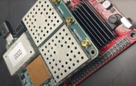
The AL2 technology for Hovermap, using Velodyne lidar sensors, is designed to rapidly map, navigate and collect data in challenging inaccessible environments such as mines. Source: Emesent
Autonomy Level 2 applications in mining and beyond
Autonomy Level 2 can help companies rapidly map, navigate, and collect data in environments such as mines, construction sites, telecommunications infrastructure, and disaster-response situations, said Emesent.
“As soon as we started demonstrating plug-and-play capability at CSIRO, we got interest from mining companies,” Hrabar said. “The speed of data capture is much quicker and safer than the current method of cavity measurement, which is sending surveyors into challenging environments with a sensor on a pole.”
“The quality of the data for calculating volume blew them away, and it can lead to new insights that were not possible before,” he said. “It can assess if there are any areas that are dangerous, like rocks coming down. The air blast from a rockfall can kill people. Our system is the most tested and commercially used underground drone in the world. We expect to see more and more autonomous systems underground, where the regulations are different than in airspace.”
“For us, Autonomy Level 3 would be full exploration — mission-specific, single-click autonomy without needing a guide, like Level 5 in the self-driving space,” he said. “We have a proof of concept of a drone taking off, finding a telecommunications tower, executing a spiral trajectory to take inspection images, and landing. Next year, we hope to release Level 3 capability for mining.”
In addition, Emesent has received requests for its UAV technology in other industrial uses. “One company is using Hovermap for demonstrating stadium disinfection,” said Hrabar. “It’s a dual-drone setup — a hose goes from the first drone to a second one, and Hovermap is providing stabilization and obstacle avoidance.”
“Warehouses are a fairly common inquiry, but there are others in that space,” he noted. “Our most exotic request was a documentary company in the U.S. looking for a drone to fly into a cave looking for a yeti.”
Emesent, which has about 40 staffers and is hiring, expects to eventually raise funding as it commercializes its Autonomy Level 2 technology. “One half of our vision is to automate data collection, then to automate analysis,” Hrabar said. “A drone would autonomously apply analytics to data, then adapt its flight plan in real time to collect the best data — we’d like to close that loop.”


Tell Us What You Think!