The Robot Report

  • Home
  • News
  • Technologies
    • Batteries / Power Supplies
    • Cameras / Imaging / Vision
    • Controllers
    • End Effectors
    • Microprocessors / SoCs
    • Motion Control
    • Sensors
    • Soft Robotics
    • Software / Simulation
  • Development
    • Artificial Intelligence
    • Human Robot Interaction / Haptics
    • Mobility / Navigation
    • Research
  • Robots
    • AGVs
    • AMRs
    • Consumer
    • Collaborative Robots
    • Drones
    • Exoskeletons
    • Industrial
    • Self-Driving Vehicles
    • Unmanned Maritime Systems
  • Markets
    • Agriculture
    • Healthcare
    • Logistics
    • Manufacturing
    • Mining
    • Security
  • Financial
    • Investments
    • Mergers & Acquisitions
    • Earnings
  • Resources
    • Careers
    • COVID-19
    • Digital Issues
    • Publications
      • Collaborative Robotics Trends
      • Robotics Business Review
    • RBR50 Winners 2022
    • Search Robotics Database
    • Videos
    • Webinars / Digital Events
  • Events
    • RoboBusiness
    • Robotics Summit & Expo
    • Healthcare Robotics Engineering Forum
    • DeviceTalks
    • R&D 100
    • Robotics Weeks
  • Podcast
    • Episodes
    • Leave a voicemail

NASA needs your help identifying features on Mars

By Brianna Wessling | November 10, 2021

Listen to this article
Voiced by Amazon Polly
AI4Mars Perseverance Rover

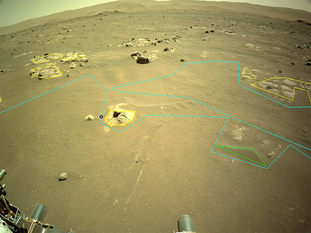
Mars as seen from the Perseverance Rover. Members of the public can now classify different types of terrain in these images by drawing polygons around the areas with AI4Mars. | Photo Credit: NASA/JPL-Caltech

NASA is expanding its AI4Mars program with new images from the Perseverance rover exploring Mars. Once again, they’re looking to the public to help teach their robots.

After last year’s launch of AI4Mars, NASA developed the Soil Property and Object Classification (SPOC) with images from the Curiosity rover. All machine learning requires teaching, and with SPOC, anyone on earth could teach NASA’s AI to recognize geological features on Mars.

Originally, landscapes could be organized into four general categories, sand, soil, bedrock and big rock.

During the first stage of AI4Mars, members of the public helped to label nearly half a million images from the Curiosity rover. The program learned to properly identify sand, rock, and soil 98% of the time.

Now, the program includes more detailed labels, like islands of rock called float rocks or nodules of minerals. Using the Zooniverse program, designed to be simple enough for fourth graders to understand and use, anyone can draw polygons over images from Perseverance and label them as 6 new types of terrain.

The Perseverance rover is equipped with 19 cameras, and one of the most powerful self-driving systems to be sent into space, AutoNav. The Perseverance rover took its first AutoNav drive in July 2021, and is tasked with finding signs of ancient microbial life on Mars.

With no road maps on Mars, I’m building my own as I go. There are lots of places I want to explore, and mapping while I drive will help me see and do more. Let the road trip begin. pic.twitter.com/cCaaV3M9Gs

— NASA's Perseverance Mars Rover (@NASAPersevere) May 28, 2021

AutoNav works by developing 3D maps of the terrain ahead and responding to that as it moves. AutoNav works faster than any navigation system a rover has been equipped with before because of its ability to think and move at the same time. The Perseverance rover can move at a top speed of 393 feet per hour, while the Curiosity rover could only move at 66 feet per hour.

However, it has trouble distinguishing types of terrain that can be hazardous for rovers, like sandy areas, and scientists still need to identify areas that could be of interest.

Perseverance sends NASA anywhere from dozens to hundreds of images every day, and scientists only have hours to respond with instructions if they see something of interest.

SPOC is still in development, and would help to reduce the number of images coming back to earth, by giving the rover the capability to identify areas of interest on its own. Essentially, it’ll save NASA scientists time in planning routes for their rovers and in finding important formations.

“It would save us time if there was an algorithm that could say, ‘I think I saw rock veins or nodules over here,’ and then the science team can look at those areas with more detail,” said Vivian Sun, a JPL scientist who consulted on the AI4Mars project.

NASA needs help identifying features in about 20,000 images to make SPOC more sophisticated, in the hopes it can be used on a future expedition.

NASA launched the Perseverance rover in July of 2020 and it made its landing on Mars in February 2021. Perseverance is exploring the Jezero crater. In September 2021, the rover cored its first rock sample on Mars.

About The Author

Brianna Wessling

Brianna Wessling is an Associate Editor, Robotics, WTWH Media. She joined WTWH Media in November 2021, and is a recent graduate from the University of Kansas. She can be reached at [email protected]

Tell Us What You Think! Cancel reply

This site uses Akismet to reduce spam. Learn how your comment data is processed.

Related Articles Read More >

NASA’s Ingenuity helicopter spots Perseverance debris
perseverance eclipse
Watch: Perseverance’s view of a solar eclipse on Mars
mars rover
Perseverance completes first multiple-sol drive
the mars2020 mission control room at JPL
A look back at the Mars 2020 landing

2021 Robotics Handbook

The Robot Report Listing Database

Latest Robotics News

Robot Report Podcast

Robotics Summit 2022 recap
See More >

Sponsored Content

  • Meet Trey, the autonomous trailer (un)loading forklift
  • Kinova Robotics launches Link 6, the first Canadian industrial collaborative robot
  • Torque sensors help make human/robot collaborations safer for workers
  • Roller screws unlock peak performance in robotic applications
  • Making the ROS development cycle manageable

RBR50 Innovation Awards

Leave us a voicemail

The Robot Report
  • Mobile Robot Guide
  • Collaborative Robotics Trends
  • Field Robotics Forum
  • Healthcare Robotics Engineering Forum
  • RoboBusiness Event
  • Robotics Business Review
  • Robotics Summit & Expo
  • About The Robot Report
  • Subscribe
  • Advertising
  • Contact Us

Copyright © 2022 WTWH Media LLC. All Rights Reserved. The material on this site may not be reproduced, distributed, transmitted, cached or otherwise used, except with the prior written permission of WTWH Media
Privacy Policy | Advertising | About Us

Search The Robot Report

  • Home
  • News
  • Technologies
    • Batteries / Power Supplies
    • Cameras / Imaging / Vision
    • Controllers
    • End Effectors
    • Microprocessors / SoCs
    • Motion Control
    • Sensors
    • Soft Robotics
    • Software / Simulation
  • Development
    • Artificial Intelligence
    • Human Robot Interaction / Haptics
    • Mobility / Navigation
    • Research
  • Robots
    • AGVs
    • AMRs
    • Consumer
    • Collaborative Robots
    • Drones
    • Exoskeletons
    • Industrial
    • Self-Driving Vehicles
    • Unmanned Maritime Systems
  • Markets
    • Agriculture
    • Healthcare
    • Logistics
    • Manufacturing
    • Mining
    • Security
  • Financial
    • Investments
    • Mergers & Acquisitions
    • Earnings
  • Resources
    • Careers
    • COVID-19
    • Digital Issues
    • Publications
      • Collaborative Robotics Trends
      • Robotics Business Review
    • RBR50 Winners 2022
    • Search Robotics Database
    • Videos
    • Webinars / Digital Events
  • Events
    • RoboBusiness
    • Robotics Summit & Expo
    • Healthcare Robotics Engineering Forum
    • DeviceTalks
    • R&D 100
    • Robotics Weeks
  • Podcast
    • Episodes
    • Leave a voicemail