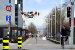
Owners of some 20 vehicles who were recently cornered by wildfires on a freeway near Los Angeles probably don’t have much good to say about aerial drones. For up to 20 minutes, five hobbyist drones prevented California firefighters from sending helicopters with water buckets over a stretch of I-5 while the flames raged. The consequence was several torched cars and “panic among motorists who fled on foot,” according to CNN.
Firefighters aren’t the only ones having problems with errant UAVs. Recently a  Skyjet Aviation flight hit a drone while on approach to Jean Lesage Airport in Canada’s Quebec City. Fortunately, the aircraft suffered only minor damage and no one was injured. The incident appears to have violated numerous regulations aimed at preventing such mishaps. Canadian authorities report that to date there have been 1,596 drone incidents in that country.
Civil penalties for flying a UAV in a fire zone under FAA flight restrictions can reach $27,500, and perpetrators also run the risk of doing prison time. But apparently, such threats aren’t enough to stop aerial gawkers. That is one reason why The U.S. Interior Dept. recently partnered with drone makers and digital mapping firms to come up with a prototype warning system that provides real-time alerts and alarms about firefighting operations. The agency developed the test system with drone maker DJI and navigational service providers AirMap and Skyward. Given the growing dangers of drones flying through forbidden airspace, the Interior Dept.’s program could be a harbinger of measures eventually adopted nationwide.
The Interior Dept.’s so-called geofencing system builds on one already installed on DJI UAVs. Today, DJI drones will, by default, not fly into or take off in locations that raise safety or security concerns. But users who have verified DJI accounts can temporarily unlock or self-authorize flights in some of those locations, though not in prohibited areas or sensitive national-security locations such as Washington, D.C.
To interact with a geofence, a drone must contain a GPS and autopilot software. During or before flight, it must download nearby “no-fly-zone” information in terms of latitudes and longitudes. As the drone flies, its autopilot continually computes the distance from the drone to forbidden areas. When it reaches a boundary, the autopilot must either stop, maneuver away, and/or tell the operator to do something.
Future versions of geofencing may allow authorities to ground drones if they enter restricted airspace. But there are problems with geofencing. One is that the boundaries of prohibited areas sometimes overlap in complicated ways. Many no-fly areas are not simple geometric shapes and straight lines but instead follow rivers, roads, or other geographical features. So the no-fly zones end up looking like ink blots on Rorschach tests. Navigating through the resulting mazes can be tricky.
There are other difficulties as well. Aviation industry observers point out that sometimes GPS reception can be unreliable. The FAA will issue Notice to Airmen (NOTAMs) about GPS degradation in specific areas, but it is not clear how many drone operators are savvy enough to check for NOTAMs before they fly.
Additionally, an operator may lose control of a drone if the automatic control kicks in during a brush with a no-fly boundary. That could be a problem if the drone needs to be maneuvered suddenly to avoid a mid-air collision.
Finally, manually controlled drones lacking GPS can’t observe geofences. So get ready for simple drones to either start carrying more expensive navigation gear or be legislated out of the sky.


Tell Us What You Think!